


Peering out at California’s San Gabriel Mountains through the windows of my cabin, I can still recall the massive wildfire that incinerated more than 40,000 hectares of Angeles National Forest in 2020. As colossal columns of smoke rose above the ridge line, newsreaders reported that no homes had been destroyed and that the blaze had not caused any injuries. That was blatantly untrue.
Countless forest residents — from rabbits and squirrels to coyotes (Canis latrans) and pumas (Puma concolor) — were killed or maimed in the megafire, and the areas they once called home were reduced to ash. However, it seemed that these casualties didn’t count, because only places where humans live were deemed inhabited. By contrast, the millions of animal species we share the planet with — what naturalist Henry Beston called the “other nations” of our world in his book The Outermost House (1928) — are too often dismissed as living brief and transitory lives in the supposedly uninhabited wilderness.
AI is helping to decode animals’ speech. Will it also let us talk with them?

This distinction between humans and the rest of the animal kingdom is proving increasingly difficult to defend. Fresh insights into the deep relationships that animals have with the land, air and sea are emerging from ambitious studies that combine GPS data, precise satellite imagery and artificial-intelligence systems.
As well as tracking animal movements, these technologies are revealing the relationships, resources, conflict zones, knowledge hubs, borders and landmarks that give all creatures a ‘sense of place’. Such knowledge can empower wildlife-conservation efforts. Ultimately, these advances could enable humanity to “listen to the animals and hear what they have to say”, notes Jewlya Samaniego, an ethnobotanist at the Wallis Annenberg Wildlife Crossing Native Plant Nursery in Agoura Hills, California. GPS tracking data of pumas and other animals have helped to demonstrate the need to build Samaniego’s ‘vegetated bridge’, which will be the largest wildlife crossing on Earth when it opens in December.
Here are more ways technology is rewriting humanity’s relationship with the natural world.
Fire hose of data
A generation ago, a zoologist would have been delighted to receive a location signal from a GPS tracker once a day. Now, an ultralight tag on a mammal or bird can broadcast its location every second. Moreover, 3D maps of such data are revealing sophisticated and often surprising behavioural patterns.
For example, after years of fieldwork, behavioural ecologist Meg Crofoot and her colleagues at the Max Planck Institute of Animal Behavior in Konstanz, Germany, concluded that kinkajous (Potos flavus) in the Panamanian rainforest return to the same fruit trees for food every day, suggesting that these trees must be key landmarks on the arboreal animals’ cognitive map. But modern tags have revealed much more: the kinkajous also seem to travel across the forest by walking along the exact same branches — a network of well-established aerial trails runs through the treetops.
This finding raises another question: how do they move so deliberately? Crofoot’s current theory is that the kinkajous might scent-mark their preferred trails like ants do, transforming the forest into a lattice of invisible viaducts.


Fellow Max Planck ecologist Martin Wikelski is scaling up GPS tracking, aiming to follow potentially millions of animals worldwide, from antelopes to falcons, with the goal of monitoring the “pulse of the living planet”. His international initiative, ICARUS, uses tiny tags and powerful receivers installed on shoebox-sized satellites called CubeSats.
CubeSat launches are now under way, and in May, I joined Wikelski at the Vandenberg Space Force Base in California to watch one depart for its new home, 500 kilometres above the animals it will observe. Others will be sent up over the next 18 months to achieve global coverage. Wikelski anticipates that this network could track members of at least 40% of all bird species and 50% of mammalian species. For researchers studying animal behaviour, this will be like turning on the lights in a dark room.
What is the future of intelligence? The answer could lie in the story of its evolution
Wikelski aims to monitor disturbances in movement patterns in real time — like an interspecies surveillance system. Animals fleeing an area might reveal issues worth investigating, such as natural resource depletion, poaching or a disease. Humans might even be able to better predict little-understood phenomena, such as earthquakes and volcanic eruptions, through changes in wildlife behaviour.
Even at this early stage, ICARUS and similar projects are generating a fire hose of data on animal movements. Most flows into a database called Movebank, maintained by the Max Planck institute. As of April, Movebank has logged nearly 11 billion animal locations, spanning more than 1,600 species. The database grows by nearly 12 million records each day — creating a vast collection for humans and machines to potentially analyse.
Superintelligent eyes and ears
Back on the ground, technologies are listening and watching as animals navigate their worlds. Motion-sensing cameras and finely tuned acoustic devices have long served as valuable tools for spying on animals as they pass through an area. Historically, biologists had to review these recordings frame by frame or use crowdsourced volunteers, limiting how much information could be gleaned from the data.
Now, AI can handle much of that hard work, rapidly identifying and logging animals from hummingbirds to rhinoceroses by sound or appearance, and pinging researchers’ phones whenever their species of interest is spotted.
Such systems can also assess whole animal populations. A trained AI tool took some 50 hours to analyse around 45 hours of raw camera footage obtained at the Kasanka National Park in Zambia, counting the number of straw-coloured fruit bats (Eidolon helvum) flying around. The average over five days: 857,233 bats. That makes the colony one of Africa’s largest. It would have taken humans an estimated 13 years to do the analysis or, more likely, it wouldn’t have been done at all.
But such population counts matter, scientists say, because these fruit bats disperse seeds over distances of more than 75 kilometres — three times farther than an African elephant (Loxodonta spp.) does. The larger the colony, the more seeds are dispersed. In other words, counting bats is a measure of the health of the entire ecosystem.


AI-powered surveillance tools can also help land managers to identify and reduce conflicts between people and wildlife. When an analysis showed that fences along Scottish rail lines were disrupting the passage of local hedgehogs (Erinaceus spp.), workers cut small holes — dubbed hedgehog highways — in the fencing to allow the animals through.
AI has similarly supercharged the once-tedious work of scanning satellite imagery for signs of ecosystem engineering. In 2007, ecologist Jean Thie at EcoInformatics in Wakefield, Canada, manually scoured high-resolution images to identify Earth’s longest beaver dam — which stretches for more than 800 metres. From the ground, it’s hard to spot the dam and the area simply looks like a large pond, whereas, viewed from above, the beaver-engineered canals and family lodges are clearly visible.
Birds get a bad rap: why we should look up to our feathered friends
Nearly two decades on, AI has begun to automate Thie’s successful technique for identifying beaver homesteads. Geographer Emily Fairfax, now at the University of Minnesota in Minneapolis, worked with a team at Google in Mountain View, California, to develop EEAGER, a machine-learning tool for identifying beaver dams1. Fairfax and her colleagues have shown that the animals’ presence is linked to enhanced biodiversity, improved water quality, wildfire mitigation and carbon sequestration.
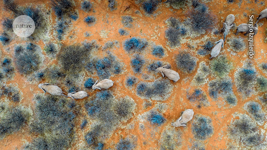
Furthermore, camera-equipped drones have been used to conduct instant animal censuses. For example, field researchers can fly aerial cameras over a popular watering hole and then use algorithms to identify the species gathered there and estimate the age and sex of the individuals. No tracking tags, no traps — just eyes in the sky trained in what to look for.
In some cases, instead of merely labelling a striped mammal as a zebra (Equus spp.), an AI system can even identify exactly which individual it has spotted2. These tools can also work out whether animal groups are visiting an area to forage or whether their movements are part of a well-established transit corridor. They do so by studying the animals’ behaviour together with environmental features, such as landscape topography and wildlife trails3. These clues collectively reveal not just who lives where, but why.
Crowdsourced connections
نشر لأول مرة على: www.nature.com
تاريخ النشر: 2026-06-15 06:00:00
الكاتب: Ryan Huling
تنويه من موقع “beiruttime-lb.com”:
تم جلب هذا المحتوى بشكل آلي من المصدر: www.nature.com بتاريخ: 2026-06-15 06:00:00. الآراء والمعلومات الواردة في هذا المقال لا تعبر بالضرورة عن رأي موقع “beiruttime-lb.com”، والمسؤولية الكاملة تقع على عاتق المصدر الأصلي.
ملاحظة: قد يتم استخدام الترجمة الآلية في بعض الأحيان لتوفير هذا المحتوى.