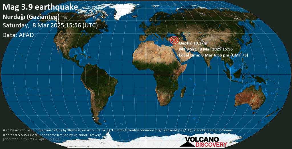
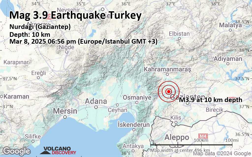
Light Mag. 3.9 Earthquake – Turkey: Nurdağı (Gaziantep) on Saturday, Mar 8, 2025, at 06:56 pm (Istanbul Time)

“)}}async sortTable(e){if(this.isSorting)return;this.isSorting=1,this.table.rows(0).style.opacity=.5,(“mag”==e||”dep”==e)&&this.isMainTable&&!this.hasLoadedAll&&”function”==typeof loadMoreRows&&(this.hasLoadedAll=1,this.isSorting=0,this.loadMoreRows(),await new Promise(e=>setTimeout(e,1e3))),await new Promise(e=>setTimeout(e,200));let s=this.table,a=Array.from(s.querySelectorAll(“:scope > tbody > tr”));a.shift();let l=”desc”,r=e==this.sortBy;for(let n of(r&&”desc”==this.sortDir&&(l=”asc”),this.sortBy=e,this.sortDir=l,a.sort((s,a)=>{if(“time”==e){let r=parseInt(s.getAttribute(“data-time”)),n=parseInt(a.getAttribute(“data-time”));return”asc”==l?r-n:n-r}if(“dep”==e){let o=parseInt(s.getAttribute(“data-dep”)),d=parseInt(a.getAttribute(“data-dep”));return”asc”==l?o-d:d-o}let h=parseFloat(s.getAttribute(“data-mag”));isNaN(h)&&(h=0);let u=parseFloat(a.getAttribute(“data-mag”));return isNaN(u)&&(u=0),”asc”==l?h-u:u-h}),a))(“tSpc”==n.className||1==n.getAttribute(“data-ea”))&&(“time”==e?n.style.display=””:n.style.display=”none”),s.tBodies(0).appendChild(n);this.table.rows(0).style.opacity=1,this.isSorting=0,this.applyFilters()}async changeCircleSize(e){let s=this.map;s.circleScale*=e;for(let a=0;atimeAtCurRow?posFound=1:(elToInsertAfter=rows(curRowInd),curRowInd++)}else posFound=1;markThem&&(newTableRow.classList.add(“newQuake”),setTimeout(function(){removeMarking(newTableRow)},8e3)),elToInsertAfter.parentNode.insertBefore(newTableRow,elToInsertAfter.nextSibling),elToInsertAfter=rows(curRowInd),curRowInd++,newRows++,”undefined”!=typeof addQuakeToMap?eval(quake.js):setTimeout(function(){eval(quake.js)},100)}return newRows+updated>0&&(this.alternateBg(),”time”==this.sortBy&&”asc”==this.sortDir&&this.sortTable(“time”)),(newRows,updated)}assignMap(e){this.map=e}}

I felt this quake

Hint: Click on the image to see different maps of this quake!
8 Mar 16:01 UTC: First to report: EMSC after 6 minutes.
8 Mar 16:03: Magnitude recalculated from 3.6 to 3.8. Hypocenter depth recalculated from 6.00 to 10.10 km (from 3.7 to 6.3 mi). Epicenter location corrected by 6.2 km (3.8 mi) towards WSW.
8 Mar 16:04: Now using data updates from AFAD
I felt this quake
Earthquake details
| Date & time | Mar 8, 2025 15:56:16 UTC – |
| Local time at epicenter | Saturday, Mar 8, 2025, at 06:56 pm (Europe/Istanbul GMT +3) |
| Status | Preliminary (automatic detection) |
| Magnitude | 3.9 |
| Depth | 10.1 km |
| Epicenter latitude / longitude | 37.2653°N / 36.9528°E Also near:
|
| Seismic antipode | 37.2653°S / 143.047°W |
| Quality | 30 seismic stations (EMSC) |
| Shaking intensity | IV Light shaking near epicenter |
| Felt | 0 reports |
| Primary data source | AFAD (Disaster and Emergency Management Authority) |
| Nearest volcano | Koruhüyüğü (59 km / 37 mi) |
| Weather at epicenter at time of quake | Overcast Clouds  13°C (55 F), humidity: 50%, wind: 2 m/s (5 kts) from SE 13°C (55 F), humidity: 50%, wind: 2 m/s (5 kts) from SE |
| Estimated seismic energy released | 4.5 x 10¹⁰ joules (12.4 megawatt hours, equivalent to 10.7 tons of TNT) | equivalent to ONE quake of magnitude 3.9 | about seismic energy |
52 minutes ago
Mar 8, 2025 15:56 GMT / Mar 8, 2025 06:56 pm (Istanbul time)
Lat / Lng: 37.26528 / 36.95278: Turkey: Nurdağı (Gaziantep)
Source: AFAD
Other sources: KOERI-RETMC: 3.7 / 8.3 km, EMSC: 3.8 / 10.1 km”;storedMarkers.push((‘quake-21536232′,37.26528,36.95278,’52 minutes ago: Mag. 3.9, Turkey: Nurdağı (Gaziantep)’,html,’quakes-5-24.png’,18,18,9,9,124));
function mkRep(id,notFelt){var nFelt=notFelt||false;var src=”https://www.volcanoesandearthquakes.com/app/earthquake-report.php?quakeId=”+id;if(nFelt==true){src+=”¬Felt=true”;}window.open(src,””,”status=0,toolbar=0,location=0,directories=0,menubar=0,resizable=1,scrollbars=1,height=400,width=350″);}
function locationHashChanged(e){-1!=e.oldURL.indexOf(“#popupMap”)&&closePopup()}
window.onhashchange = locationHashChanged;
function comment(e){var t=e.parentNode,a=(t.dataset.id,document.getElementById(“commentForm”));”none”==a.style.display?(t.appendChild(a),a.style.display=”block”):a.style.display=”none”}function sendComment(e){var t=e.parentNode,a=t.parentNode.dataset.id,n=document.getElementById(“commentContent”),p=n.value.trim();if(p){var o=”id=”+a+”&quakeId=”+thisQuakeId;o+=”&comment=”+decodeURIComponent(p),mkRequest(“//reports.volcanodiscovery.com/app/eqReportComment.php”,”post”,o,function(e){e.responseText;alert(“Thank you for submitting your comment!”),t.style.display=”none”,n.value=””})}}function flagReport(e){var t=e.parentNode.dataset.id;if(confirm(“Report this as inappropriate?”)){var a=”id=”+t+”&quakeId=”+thisQuakeId+”&flagAsInappropriate=1″;mkRequest(“//reports.volcanodiscovery.com/app/eqReportComment.php”,”post”,a,function
(smaller) (bigger)
Nearby places
The closest larger town where the quake might have been felt is Gaziantep, a city of 1.8 million people in Turkey, in 45 km (28 mi) distance southeast of the epicenter. People likely experienced weak shaking there. Many smaller towns and villages are located closer to the epicenter and might have experienced stronger shaking. In the capital of ![]() Turkey, Ankara, 463 km (287 mi) away from the epicenter, the earthquake could not be felt.
Turkey, Ankara, 463 km (287 mi) away from the epicenter, the earthquake could not be felt.
The following table shows some of the places that might have been affected (or not) by the shaking.
Distance |
Place | Max. shaking intensity(*) | Region | Country |
|---|---|---|---|---|
| 14 km (8 mi)S of epicenter | Hisarkoey(pop: 1000) |
III: Weak |
Gaziantep | |
| 22 km (14 mi)
SW of epicenter |
Nurdagi
(pop: 12,800) |
III: Weak |
Gaziantep | |
| 34 km (21 mi)
SW of epicenter |
Fevzipasa
(pop: 1,170) |
III: Weak |
Gaziantep | |
| 34 km (21 mi)
W of epicenter |
Bahce
(pop: 13,100) |
III: Weak |
Adana | |
| 34 km (21 mi)
S of epicenter |
Kozlubağ
(pop: 179) |
III: Weak |
Kilis | |
| 36 km (22 mi)
N of epicenter |
Kahramanmaras
(pop: 385,000) |
III: Weak |
Kahramanmaras | |
| 36 km (22 mi)
SE of epicenter |
Doğanca
(pop: 284) |
III: Weak |
Gaziantep | |
| 37 km (23 mi)
SW of epicenter |
Karakaya
(pop: 357) |
III: Weak |
Gaziantep | |
| 39 km (24 mi)
NE of epicenter |
Pazarcık
(pop: 23,900) |
III: Weak |
Kahramanmaras | |
| 45 km (28 mi)
SE of epicenter |
Gaziantep
(pop: 1,808,900) |
III: Weak |
Gaziantep | |
| 47 km (29 mi)
S of epicenter |
Ispanak
(pop: 799) |
III: Weak |
Kilis | |
| 49 km (31 mi)
S of epicenter |
Karaçavuş
(pop: 372) |
III: Weak |
Kilis | |
| 50 km (31 mi)
SE of epicenter |
Deredüzü
(pop: 263) |
III: Weak |
Gaziantep | |
| 54 km (34 mi)
SW of epicenter |
Yesilyurt
(pop: 3,920) |
II: Very weak |
Gaziantep | |
| 55 km (34 mi)
E of epicenter |
Yavuzeli
(pop: 8,170) |
II: Very weak |
Gaziantep | |
| 55 km (34 mi)
SW of epicenter |
Yağızlar
(pop: 455) |
II: Very weak |
Gaziantep | |
| 60 km (37 mi)
SE of epicenter |
Oguzeli
(pop: 11,500) |
II: Very weak |
Gaziantep | |
| 61 km (38 mi)
NE of epicenter |
Cagliyan Cerit
(pop: 15,500) |
II: Very weak |
Kahramanmaras | |
| 63 km (39 mi)
NW of epicenter |
Andırın
(pop: 8,660) |
II: Very weak |
Kahramanmaras | |
| 65 km (40 mi)
SW of epicenter |
Hassa
(pop: 9,720) |
II: Very weak |
Hatay | |
| 68 km (42 mi)
E of epicenter |
Araban
(pop: 11,100) |
II: Very weak |
Gaziantep | |
| 68 km (42 mi)
SE of epicenter |
Gundogan
(pop: 539) |
II: Very weak |
Gaziantep | |
| 68 km (42 mi)
SE of epicenter |
İnceyol
(pop: 166) |
II: Very weak |
Gaziantep | |
| 74 km (46 mi)
SE of epicenter |
Uluyatir
(pop: 3,350) |
II: Very weak |
Gaziantep | |
| 75 km (47 mi)
SW of epicenter |
Erzin
(pop: 26,300) |
II: Very weak |
Hatay | |
| 79 km (49 mi)
SE of epicenter |
Dibecik
(pop: 434) |
II: Very weak |
Gaziantep | |
| 80 km (50 mi)
SW of epicenter |
Dörtyol
(pop: 56,500) |
II: Very weak |
Hatay | |
| 83 km (52 mi)
NE of epicenter |
Golbasi
(pop: 28,100) |
II: Very weak |
Adiyaman | |
| 84 km (52 mi)
SW of epicenter |
Balarmudu
(pop: 676) |
II: Very weak |
Hatay | |
| 96 km (59 mi)
SW of epicenter |
Denizciler
(pop: 17,500) |
II: Very weak |
Hatay | |
| 463 km (287 mi)
NW of epicenter |
Ankara
(pop: 3,517,200) |
: Not felt |
Ankara |
Notes:
(*) Shaking intensity according to the Modified Mercalli Intensity Scale (MMI) and estimated using seismic models.
User-reports for this quake
There are no user reports for this quake yet.If you felt it, be the first to report it!
Contribute:
Leave a comment if you find a particular report interesting or want to add to it.
Flag as inappropriate.
Mark as helpful or interesting.
Send your own user report!
Compare Quake Data
Data for the same earthquake as reported by different agencies
The more agencies report about the same quake and post similar data, the more confidence you can have in the data. It takes normally up to a few hours until earthquake parameters are calculated with near-optimum precision.
| Mag | Depth | Time GMT
2025-03-8 |
Epicenter | Agency |
|---|---|---|---|---|
| 3.9 | 10.1 km
6.3 mi |
15:56:16 | Nurdağı (Gaziantep) | AFAD (Disaster and Emergency Management Authority) |
| 3.7 | 8.3 km
5.2 mi |
15:56:16 | INCIRLI-NURDAGI (GAZIANTEP)
0.9 km (0.5 mi) epicenter difference with AFAD |
KOERI-RETMC (Kandilli Oservatory and Earthquake Research Institute in Istanbul) |
| 3.8 | 10.1 km
6.3 mi |
15:56:16 | CENTRAL TURKEY
0 km (0 mi) epicenter difference with AFAD |
EMSC (European-Mediterranean Seismological Centre) |
“;
HTMLcontent += “
“;
mainMap.addToMap(“station”+id, lat, lon, title,HTMLcontent);
mainMap.map.panTo((lat,lon));
document.getElementById(“map_canvas”).scrollIntoView();
}
Seismograms
Show more
Show less
Earthquake statistics
Average number of earthquakes
Based on data from the past 55 years and our earthquake archive back to 1900, there are about 3,800 quakes on average per year in the area near the epicenter of this quake (within 100 km/61 mi):
- Mag. 7 or higher: 0.02 quakes per year (or 1 quake every 62.5 years)
- Mag. 6 or higher: 0.04 quakes per year (or 1 quake every 25 years)
- Mag. 5 or higher: 0.64 quakes per year (or 1 quake every 1.6 years)
- Mag. 4 or higher: 54 quakes per year (or 4.5 quakes per month)
- Mag. 3 or higher: 305 quakes per year (or 25.4 quakes per month)
- Mag. 2 or higher: 1,500 quakes per year (or 4.2 quakes per day)
- Mag. 1 or higher: 3,700 quakes per year (or 10.1 quakes per day)
The area where this quake occurred has a high level of seismic activity. It has had at least 2 quakes above magnitude 7 since 1900, which suggests that larger earthquakes of this size occur infrequently, probably on average approximately every 60 to 65 years.
Number of quakes per year
Previous quakes in the same area of this earthquake
The earthquake occurred 14 weeks after a magnitude 4.1 earthquake had hit on Thursday, Nov 28, 2024, at 10:12 am local time (Europe/Istanbul GMT +3) in 91 km (56 mi) distance to the north:
The strongest-ever (since 1900) recorded quake in this area measured magnitude 7.8. It had occurred 2 years ago earlier, on Monday, Feb 6, 2023, at 04:17 am local time (Europe/Istanbul GMT +3) in Gaziantep, ![]() Turkey:
Turkey:
Below is a list and map of (larger or recent) quakes that had occurred near the area of the epicenter before this earthquake (within up to 100 km/61 mi distance, up to 300 km/183 mi for very large quakes above mag. 7). Filter the list to limit the number to show, by magnitude or time before.
Max results10
2050100
All
Magnitude
All2+
3+4+5+
6+7+8+
Time before
48 hours
1 week
30 days
1 year
5 years
30 years
Any age
Date and Time |
Mag Depth |
Distance | Location | Details | Map |
|---|---|---|---|---|---|
| Mar 7, 03:39 pm (Istanbul) |
3.3 6.8 km |
90 km (56 mi) to the N |
Info |
||
| Mar 7, 09:45 am (Istanbul) |
3.6 7 km |
95 km (59 mi) to the SW |
Info |
||
| Mar 2, 11:34 pm (GMT +3) |
3.1 7 km |
98 km (61 mi) to the N |
Info |
||
| Feb 24, 03:09 am (GMT +3) |
3.1 9.4 km |
99 km (62 mi) to the NW |
Info |
||
| Feb 22, 06:29 pm (Istanbul) |
3.3 7 km |
59 km (37 mi) to the W |
Info |
||
| Nov 28, 2024 10:12 am (Istanbul) |
4.1 10.8 km |
91 km (56 mi) to the N | Info | ||
| Nov 15, 2024 07:56 pm (Istanbul) |
3.9 7.1 km |
98 km (61 mi) to the NE |
Info |
||
| Nov 15, 2024 10:46 am (Istanbul) |
4.9 6.6 km |
96 km (60 mi) to the NE | Info | ||
| Oct 27, 2024 08:07 pm (Istanbul) |
4.9 10 km |
93 km (58 mi) to the NW | Info | ||
| Oct 24, 2024 09:04 pm (Istanbul) |
3.9 7 km |
80 km (50 mi) to the N |
Info |
||
| Sep 7, 2024 09:31 am (Istanbul) |
5.0 4.1 km |
10.9 km (6.8 mi) to the NE | Info | ||
| Jul 25, 2023 08:44 am (Istanbul) |
5.5 13 km |
95 km (59 mi) to the W | Info | ||
| Feb 8, 2023 02:11 pm (Istanbul) |
5.4 9.6 km |
98 km (61 mi) to the NE | Info | ||
| Feb 7, 2023 06:13 am (Istanbul) |
5.5 10 km |
88 km (55 mi) to the NE | Info | ||
| Feb 6, 2023 03:02 pm (Istanbul) |
6.0 8.5 km |
96 km (60 mi) to the NW | Info | ||
| Feb 6, 2023 01:32 pm (Istanbul) |
5.4 14 km |
84 km (52 mi) to the N | Info | ||
| Feb 6, 2023 01:24 pm (Istanbul) |
7.5 7.4 km |
86 km (53 mi) to the N | Info | ||
| Feb 6, 2023 04:36 am (Istanbul) |
5.6 10 km |
39 km (24 mi) to the SW | Info | ||
| Feb 6, 2023 04:28 am (Istanbul) |
6.7 9.8 km |
10 km (6.2 mi) to the SW | Info | ||
| Feb 6, 2023 04:26 am (Istanbul) |
5.7 10 km |
6.1 km (3.8 mi) to the SE | Info | ||
| Feb 6, 2023 04:17 am (Istanbul) |
7.8 10 km |
7 km (4.4 mi) to the SE | Info | ||
| Oct 11, 2022 06:48 pm (Istanbul) |
5.0 10 km |
64 km (40 mi) to the W | Info | ||
| Sep 19, 2012 12:17 pm (Istanbul) |
4.9 7 km |
14 km (8.5 mi) to the E | Info | ||
| Jul 22, 2012 12:26 pm (Istanbul) |
5.0 7.6 km |
59 km (37 mi) to the NW | Info | ||
| Dec 14, 2002 01:02 am (Universal Time) |
4.9 10 km |
72 km (45 mi) to the NW | Info | ||
| Jan 21, 2002 05:33 pm (Istanbul) |
5.1 10 km |
23 km (14 mi) to the W | Info | ||
| Oct 31, 2001 03:33 pm (Istanbul) |
5.1 10 km |
72 km (45 mi) to the W | Info | ||
| Jun 25, 2001 04:28 pm (Istanbul) |
5.5 5 km |
66 km (41 mi) to the W | Info | ||
| Mar 29, 1996 08:58 am (Istanbul) |
5.0 10 km |
77 km (48 mi) to the NW | Info | ||
| Apr 10, 1991 04:08 am (Istanbul) |
5.4 10 km |
66 km (41 mi) to the W | Info | ||
| Aug 3, 1986 04:33 am (Istanbul) |
5.0 12 km |
32 km (20 mi) to the E | Info | ||
| Aug 17, 1971 07:29 am (Istanbul) |
5.2 43 km |
22 km (13 mi) to the SW | Info | ||
| Jul 11, 1971 11:12 pm (Istanbul) |
5.7 10 km |
18 km (11 mi) to the SW | Info | ||
| Jun 29, 1971 12:08 pm (Istanbul) |
5.2 35 km |
18 km (11 mi) to the S | Info | ||
| Apr 7, 1967 09:33 pm (Istanbul) |
5.2 15 km |
63 km (39 mi) to the W | Info | ||
| Apr 7, 1967 08:07 pm (Istanbul) |
5.1 15 km |
71 km (44 mi) to the W | Info | ||
| Mar 25, 1953 12:17 am (Istanbul) |
5.4 15 km |
46 km (28 mi) to the S | Info | ||
| Mar 20, 1945 10:58 am (Istanbul) |
6.1 0 km |
97 km (60 mi) to the W | Info | ||
| Feb 20, 1940 03:00 am (Istanbul) |
7.0 0 km |
179 km (112 mi) to the NW | Info | ||
| Nov 30, 1904 02:00 am (Damascus) |
7.0 0 km |
130 km (81 mi) to the S | Info |
Map of earlier quakes in the area of this quake
Max results10
2050100
All
Magnitude
All2+
3+4+5+
6+7+8+
Time before
48 hours
1 week
30 days
1 year
5 years
30 years
Any age
Oldest quakes are shown in yellow, most recent in red.
(quakes –) (quakes +) (smaller) (bigger)
52 minutes ago
Mar 8, 2025 15:56 GMT / Mar 8, 2025 06:56 pm (Istanbul time)
Lat / Lng: 37.26528 / 36.95278: Turkey: Nurdağı (Gaziantep)
Source: AFAD
Other sources: KOERI-RETMC: 3.7 / 8.3 km, EMSC: 3.8 / 10.1 km’,3.9,39, ‘#bb202a’, 0.9,1.5, ‘#bb202a’, 0.27);map2.addToMap(‘thisQuake’,37.26528,36.95278,’52 minutes ago: Mag. 3.9, Turkey: Nurdağı (Gaziantep)’,’
Earthquake: Mag 3.9 / 10 km (6.3 mi) depth
52 minutes ago
Mar 8, 2025 15:56 GMT / Mar 8, 2025 06:56 pm (Istanbul time)
Lat / Lng: 37.26528 / 36.95278: Turkey: Nurdağı (Gaziantep)
Source: AFAD
Other sources: KOERI-RETMC: 3.7 / 8.3 km, EMSC: 3.8 / 10.1 km’,’default’);
// this will be local to this table obj
function putQuakeOnMap(id,lat,lon,time,title,html,mag,zIndex) {
qTableOlder.putQuakeOnMap(id,lat,lon,time,title,html,mag,zIndex);
}
map2.circleScale=0.5;qTableOlder.usePalette=1;qTableOlder.startVal=qTableOlder.referenceTime-(80*365.25*86400);qTableOlder.endVal=qTableOlder.referenceTime;
qTableOlder.assignMap(map2);
qTableOlder.quakeIds.push(8906391);putQuakeOnMap(‘quake-8906391′,36.1,37.1,-2053987200,’Nov 30, 1904 02:00 am (GMT +2): Mag. 7.0, Rasum-kale (Near Halab); Lebanon Bayront’,”,7.0,70);qTableOlder.quakeIds.push(8906867);putQuakeOnMap(‘quake-8906867′,38.4,35.5,-942451200,’Feb 20, 1940 03:00 am (GMT +3): Mag. 7.0, Kayseri, Develi’,”,7.0,70);qTableOlder.quakeIds.push(8907002);putQuakeOnMap(‘quake-8907002′,37.244,35.859,-782150468,’Mar 20, 1945 10:58 am (GMT +3): Mag. 6.1, Aelana, Ceyhan, Adana’,”,6.1,61);qTableOlder.quakeIds.push(2943518);putQuakeOnMap(‘quake-2943518′,36.855,36.966,-529296144,’Mar 25, 1953 12:17 am (GMT +3): Mag. 5.4, Turkey-Syria border region’,”,5.4,54);qTableOlder.quakeIds.push(8923081);putQuakeOnMap(‘quake-8923081′,37.374,36.158,-86338367,’Apr 7, 1967 08:07 pm (GMT +3): Mag. 5.1, 5 km E of Kadirli, Turkey’,”,5.1,51);qTableOlder.quakeIds.push(8923080);putQuakeOnMap(‘quake-8923080′,37.313,36.243,-86333190,’Apr 7, 1967 09:33 pm (GMT +3): Mag. 5.2, 14 km ESE of Kadirli, Turkey’,”,5.2,52);qTableOlder.quakeIds.push(8924799);putQuakeOnMap(‘quake-8924799′,37.111,36.905,47034494,’Jun 29, 1971 12:08 pm (GMT +3): Mag. 5.2, 16 km ESE of Nurda??, Turkey’,”,5.2,52);qTableOlder.quakeIds.push(8924811);putQuakeOnMap(‘quake-8924811′,37.181,36.778,48111176,’Jul 11, 1971 11:12 pm (GMT +3): Mag. 5.7, 3 km ENE of Nurda??, Turkey’,”,5.7,57);qTableOlder.quakeIds.push(8924885);putQuakeOnMap(‘quake-8924885′,37.089,36.851,51251376,’Aug 17, 1971 07:29 am (GMT +3): Mag. 5.2, 13 km SE of Nurda??, Turkey’,”,5.2,52);qTableOlder.quakeIds.push(3060467);putQuakeOnMap(‘quake-3060467′,37.2,37.3,523416800,’Aug 3, 1986 04:33 am (GMT +3): Mag. 5.0, 17 km NNW of Gaziantep, Turkey’,”,5.0,50);qTableOlder.quakeIds.push(3070403);putQuakeOnMap(‘quake-3070403′,37.359,36.221,671245719,’Apr 10, 1991 04:08 am (GMT +3): Mag. 5.4, 11 km E of Kadirli, Turkey’,”,5.4,54);qTableOlder.quakeIds.push(12875292);putQuakeOnMap(‘quake-12875292′,37.76,36.34,828079132,’Mar 29, 1996 08:58 am (GMT +3): Mag. 5.0, Turkey’,”,5.0,50);qTableOlder.quakeIds.push(3099446);putQuakeOnMap(‘quake-3099446′,37.238,36.206,993475726,’Jun 25, 2001 04:28 pm (GMT +3): Mag. 5.5, central Turkey’,”,5.5,55);qTableOlder.quakeIds.push(3100819);putQuakeOnMap(‘quake-3100819′,37.249,36.136,1004531632,’Oct 31, 2001 03:33 pm (GMT +3): Mag. 5.1, central Turkey’,”,5.1,51);qTableOlder.quakeIds.push(14099144);putQuakeOnMap(‘quake-14099144′,37.3,36.7,1011623596,’Jan 21, 2002 05:33 pm (GMT +3): Mag. 5.1, Turkey’,”,5.1,51);qTableOlder.quakeIds.push(4937673);putQuakeOnMap(‘quake-4937673′,37.524,36.201,1039827763,’Dec 14, 2002 01:02 am (Universal Time): Mag. 4.9, central Turkey’,”,4.9,49);qTableOlder.quakeIds.push(4450);putQuakeOnMap(‘quake-4450′,37.546,36.384,1342949162,’Jul 22, 2012 12:26 pm (GMT +3): Mag. 5.0, 4 km SE of And?r?n, Turkey’,”,5.0,50);qTableOlder.quakeIds.push(53296);putQuakeOnMap(‘quake-53296′,37.309,37.097,1348046266,’Sep 19, 2012 12:17 pm (GMT +3): Mag. 4.9, 26 km SW of Pazarc?k, Turkey’,”,4.9,49);qTableOlder.quakeIds.push(7127809);putQuakeOnMap(‘quake-7127809′,37.2612,36.2339,1665503326,’Oct 11, 2022 06:48 pm (GMT +3): Mag. 5.0, 17 km SE of Kadirli, Turkey’,”,5.0,50);qTableOlder.quakeIds.push(7365977);putQuakeOnMap(‘quake-7365977′,37.2256,37.0143,1675646254,’Feb 6, 2023 04:17 am (GMT +3): Mag. 7.8, Pazarcik Earthquake, Kahramanmaras Earthquake Sequence’,”,7.8,78);qTableOlder.quakeIds.push(7366429);putQuakeOnMap(‘quake-7366429′,37.2252,37.0001,1675646810,’Feb 6, 2023 04:26 am (GMT +3): Mag. 5.7, 24 km ENE of Nurda??, Turkey’,”,5.7,57);qTableOlder.quakeIds.push(7366171);putQuakeOnMap(‘quake-7366171′,37.1893,36.8929,1675646895,’Feb 6, 2023 04:28 am (GMT +3): Mag. 6.7, 14 km E of Nurda??, Turkey’,”,6.7,67);qTableOlder.quakeIds.push(7366202);putQuakeOnMap(‘quake-7366202′,36.9921,36.6832,1675647387,’Feb 6, 2023 04:36 am (GMT +3): Mag. 5.6, Turkey-Syria Border Region’,”,5.6,56);qTableOlder.quakeIds.push(7367443);putQuakeOnMap(‘quake-7367443′,38.0106,37.1962,1675679088,’Feb 6, 2023 01:24 pm (GMT +3): Mag. 7.5, Elbistan Earthquake, Kahramanmaras Earthquake Sequence’,”,7.5,75);qTableOlder.quakeIds.push(9323936);putQuakeOnMap(‘quake-9323936′,37.9962,37.2033,1675679528,’Feb 6, 2023 01:32 pm (GMT +3): Mag. 5.4, 7 km S of Ekinözü, Turkey’,”,5.4,54);qTableOlder.quakeIds.push(7367779);putQuakeOnMap(‘quake-7367779′,38.0582,36.5114,1675684931,’Feb 6, 2023 03:02 pm (GMT +3): Mag. 6.0, 4 km NNE of Göksun, Turkey’,”,6.0,60);qTableOlder.quakeIds.push(7369983);putQuakeOnMap(‘quake-7369983′,37.7639,37.7309,1675739592,’Feb 7, 2023 06:13 am (GMT +3): Mag. 5.5, 8 km ESE of Gölba??, Turkey’,”,5.5,55);qTableOlder.quakeIds.push(7374002);putQuakeOnMap(‘quake-7374002′,37.9389,37.6611,1675854712,’Feb 8, 2023 02:11 pm (GMT +3): Mag. 5.4, 17 km N of Gölba??, Turkey’,”,5.4,54);qTableOlder.quakeIds.push(7770274);putQuakeOnMap(‘quake-7770274′,37.5794,35.9482,1690263891,’Jul 25, 2023 08:44 am (GMT +3): Mag. 5.5, 18 km NE of Kozan, Turkey’,”,5.5,55);qTableOlder.quakeIds.push(9592199);putQuakeOnMap(‘quake-9592199′,37.3103,37.0627,1725690670,’Sep 7, 2024 09:31 am (GMT +3): Mag. 5.0, 28 km SW of Pazarcık, Turkey’,”,5.0,50);qTableOlder.quakeIds.push(9670406);putQuakeOnMap(‘quake-9670406′,37.9397,36.6353,1729793049,’Oct 24, 2024 09:04 pm (GMT +3): Mag. 3.9, Turkey: Onikişubat (Kahramanmaraş)’,”,3.9,39);qTableOlder.quakeIds.push(9674970);putQuakeOnMap(‘quake-9674970′,37.6308,36.0057,1730048830,’Oct 27, 2024 08:07 pm (GMT +3): Mag. 4.9, 21 km SSE of Feke, Turkey’,”,4.9,49);qTableOlder.quakeIds.push(9705371);putQuakeOnMap(‘quake-9705371′,37.9554,37.6128,1731656780,’Nov 15, 2024 10:46 am (GMT +3): Mag. 4.9, 15 km E of Nurhak, Turkey’,”,4.9,49);qTableOlder.quakeIds.push(9706103);putQuakeOnMap(‘quake-9706103′,37.9889,37.5872,1731689773,’Nov 15, 2024 07:56 pm (GMT +3): Mag. 3.9, Turkey: Doğanşehir (Malatya)’,”,3.9,39);qTableOlder.quakeIds.push(9726782);putQuakeOnMap(‘quake-9726782′,38.0439,36.6522,1732777920,’Nov 28, 2024 10:12 am (GMT +3): Mag. 4.1, Göksun (Kahramanmaraş)’,”,4.1,41);qTableOlder.quakeIds.push(21380268);putQuakeOnMap(‘quake-21380268′,37.31056,36.29139,1740238151,’###AGEREP###: Mag. 3.3, Düziçi (Osmaniye)’,”,3.3,33);qTableOlder.quakeIds.push(21384626);putQuakeOnMap(‘quake-21384626′,38.07667,36.49056,1740355748,’###AGEREP###: Mag. 3.1, Göksun (Kahramanmaraş)’,”,3.1,31);qTableOlder.quakeIds.push(21514633);putQuakeOnMap(‘quake-21514633′,38.09278,36.57278,1740947644,’###AGEREP###: Mag. 3.1, Göksun (Kahramanmaraş)’,”,3.1,31);qTableOlder.quakeIds.push(21531753);putQuakeOnMap(‘quake-21531753′,36.52667,36.42139,1741329922,’###AGEREP###: Mag. 3.6, Turkey: Kırıkhan (Hatay)’,”,3.6,36);qTableOlder.quakeIds.push(21532483);putQuakeOnMap(‘quake-21532483′,38.0725,37.06667,1741351142,’###AGEREP###: Mag. 3.3, Turkey: Kandil Barajı – (02.31 Km) Ekinözü (Kahramanmaraş)’,”,3.3,33);(async function(){await new Promise(r => setTimeout(r,4000));map2.map.setZoom(7)})();
})();
JOIN US AND FOLO
Telegram
Whatsapp channel
Nabd
GOOGLE NEWS
tiktok
مصدر الخبر
نشر الخبر اول مرة على موقع :www.volcanodiscovery.com بتاريخ:2025-03-08 17:56:00
ادارة الموقع لا تتبنى وجهة نظر الكاتب او الخبر المنشور بل يقع على عاتق الناشر الاصلي
تم نشر الخبر مترجم عبر خدمة غوغل